Here’s a question that sounds simple but isn’t: if a drill bit is 3,000 metres underground, curving through rock nobody can see, how does anyone know exactly where it is?
You can’t lower a camera down and look. You can’t use GPS — it doesn’t work through kilometres of rock. Instead, the industry relies on a category of downhole tools called survey instruments, and understanding how they work is the second big building block of directional drilling (right after well profiles, which we covered in the last post).
Every survey, no matter which tool takes it, boils down to the same three numbers: measured depth, inclination, and azimuth. From those three values, and the same math we touched on last time, engineers can reconstruct the entire path of the well, point by point, all the way back to surface.
The Two Forces the Earth Gives Us For Free
Before getting into specific tools, it helps to understand what they’re actually measuring. Every survey tool leans on one (or both) of two natural reference points the Earth provides:
- Gravity — pulls everything toward the Earth’s core. A sensor package called an accelerometer measures this pull along three perpendicular axes, and from that, the tool calculates inclination — how far the wellbore has tilted from straight down.
- Magnetic North — the Earth’s magnetic field, which a magnetometer (or, in older tools, a simple compass) can sense to calculate azimuth — the compass direction the wellbore is heading.
Three accelerometers plus three magnetometers, all mounted at right angles to each other, give a complete picture of exactly which way the bottom of the drill string is pointing at that instant.
There’s a third option that doesn’t rely on magnetism at all — the gyroscope — which we’ll get to shortly, because it solves a very specific problem the magnetic tools can’t.
The Main Types of Survey Tools
Single Shot
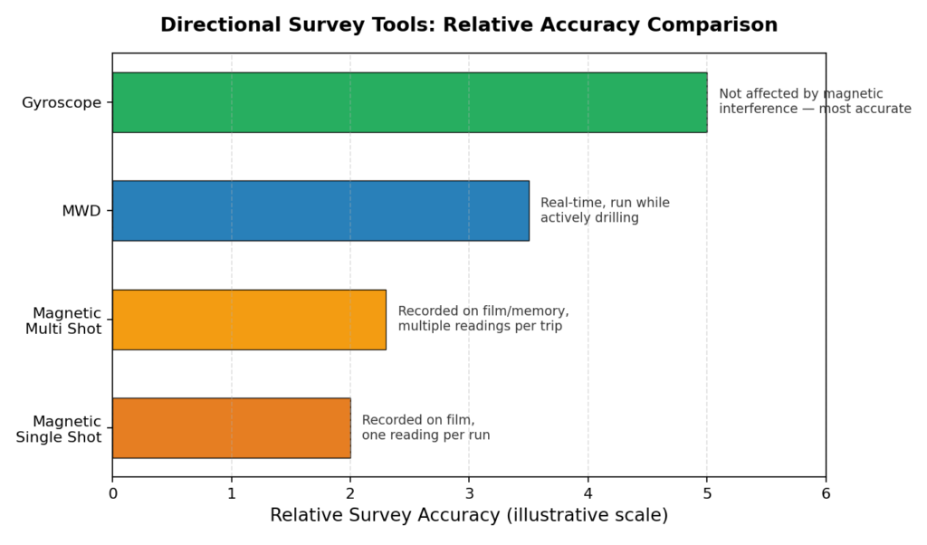
Exactly what it sounds like — a tool lowered into the well on a slickline to take one reading, then pulled back out. The classic single shot only records inclination; add a magnetic sensor and it becomes a “magnetic single shot,” which also gives azimuth. These tools are simple, cheap, and have been around for decades — some versions still use actual photographic film to record the angle and compass card.
Multi Shot
Basically the same idea, but instead of one photo, the tool takes readings continuously (every 20 seconds or so is typical) as it’s pulled out of the hole, either onto a roll of film or into digital memory. This gives a full profile of the well in a single trip instead of one data point per run.
MWD — Measurement While Drilling
This is the workhorse of modern directional drilling. An MWD tool sits in the bottom hole assembly and sends survey data to the surface in real time, while drilling is actually happening — no need to stop and run a separate tool downhole. Data usually travels up as pressure pulses through the drilling mud itself (called mud pulse telemetry), though electromagnetic and wireline telemetry exist for specific situations. Many MWD tools also carry a gamma ray sensor, so the geologist gets a live picture of the formation being drilled, not just the wellbore’s position.
Gyroscope
The gyroscope is the odd one out — it doesn’t use magnetism at all. Instead, it relies on the property of a rapidly spinning mass to stay fixed in space (called rigidity), which lets it measure direction independent of the Earth’s magnetic field entirely. That makes it the go-to tool in situations where magnetic tools simply can’t be trusted:
- Drilling near old casing, fish (lost equipment), or other magnetic junk in the hole
- Multi-well platforms with tight spacing, where anti-collision accuracy really matters
- Any time you need what the industry calls the “definitive survey” — the most accurate version of the well’s position, used as the final reference
Here’s how the four tool types stack up:
Why Magnetic Tools Can Be Fooled
Anything that relies on Earth’s magnetic field has an obvious weak point: it can be thrown off by other magnetic fields nearby. This is such a common issue in directional drilling that there’s a whole category of error dedicated to it — azimuth error — and it comes from a handful of predictable sources:
- Drill string interference — the steel drill pipe itself behaves like a big bar magnet. This effect is unavoidable, but it can be minimized.
- External interference — nearby casing, lost tools (“fish”) left in the hole, or even certain iron-rich rock formations.
- Geomagnetic disturbances — solar storms can distort the Earth’s magnetic field enough to throw off a survey by a couple of degrees, especially near the poles.
- Sensor misalignment or equipment failure — the mundane, mechanical kind of error every sensor is subject to.
The tricky part is that this error isn’t constant — it gets worse as the wellbore inclination increases, and it’s also affected by how strong the Earth’s horizontal magnetic field is at that particular location (which, confusingly, is actually weaker near the poles than you might expect, even though the total field is stronger there).
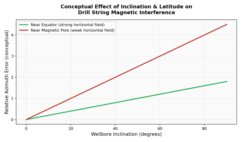
To manage all this, the industry uses a few practical fixes: non-magnetic drill collars to physically separate the sensitive sensors from the magnetic drill string, careful well azimuth planning to avoid heading due east or west (where interference is worst), and — when none of that is good enough — simply switching to a gyroscope, which sidesteps the whole problem.
There’s also a formal quality-control step built into every survey program, called survey acceptance criteria. Before a magnetic survey is trusted, its readings for total magnetic field strength, magnetic dip angle, and total gravitational field are checked against expected baseline values for that location. If a reading falls outside an accepted tolerance, the survey gets flagged as bad and retaken — nobody drills blind off a number that doesn’t check out.
Putting It Together
None of these tools work in isolation — a typical directional well might use MWD for real-time steering while drilling, then run a gyro multi-shot before drilling out of a casing shoe just to be certain of position before going directional. The tool changes depending on the risk at that stage of the well, but the underlying goal never does: know exactly where the bit is, at all times, with enough confidence to trust the well plan.
That confidence is what everything else in directional drilling depends on — the build rates, the target hits, the anti-collision checks. Get the survey wrong, and every calculation downstream is wrong with it.
Coming Up Next
Now that we know how directional drillers figure out where the bit actually is, the next post digs into the math they use to steer it — build-up rate, dogleg severity, and the slide-sheet calculations directional hands do by hand on the rig floor between surveys.
This is post 2 in an ongoing series on the fundamentals of directional drilling. Post 1 covered well profiles and the basic vocabulary of a well plan — check it out if you missed it.